
Constantinopolitana: Database of East Rome (C-DER) is an in-development relational database designed to contain a digital record of every object known to have existed in Constantinople during the Byzantine Roman Era (ca. 250-1453). Through use of the Nodegoat platform digital nodes of objects and sites are spatially and temporally linked together, and together with the people who created, (or associated with) them in an interactive digital map of the remnants of Constantinopolitan life through time.
For a description of the project as of May 2024 see this research blog post.
- Historical Note: The idea for C-DER arose from the Constantinople as Palimpsest (CPal) project which was created using ArcGIS online, and StoryMaps (see the 2017 Alpha Version here, and the 2021 Beta Version here). A narratives of that project’s development here, its DOI and archive for reference or download is on BodoArXiv here.
The C-DER project is still in development and so is not available to the public but for the time being collaborators are invited to work with us in the Nodegoat platform hosted on Wesleyan University servers. We plan a soft public launch in FALL 2026, to be followed by an open call for contributions by groups, institutions, and individuals.
What is C-DER?
C-DER is an interactive project that aims to inter-link and interactively vizualize all public-facing research about the Roman capital of Constantinople. The data framework is being constructed as a relational database in the web-based historical research environment Nodegoat. C-DER will link digital entries on every known object (whether extant today or known only from sources) to have existed in medieval Constantinople. Each object—icons, mosaics, lead seals, codices, buildings, statues, etc.—will be represented by a succinct entry and assigned a place and time on a digital map of the city. When C-DER is launched to scholars and the public, users will sort and explore the sum of our knowledge on a single map: an interactive digital topography of every known remnant of life in Constantinople.
What does C-DER contribute?
C-DER combines brief definitional entries for the public with original scholarly research to make connections between hundreds (and eventually, tens of thousands) of sources on Constantinople. C-DER expands on the rich sources of the Oxford Dictionary of Byzantium (the definitive reference of East Roman History) by creating an entirely new epistemology for historical knowledge. C-DER is thus not simply an update to Wikipedia but a re-conceptualization of how we share and store information in the twenty-first century. For more see this blog post.
What is the status of the C-DER project?
In 2025-26 the C-DER team—led by co-editors Jesse W. Torgerson and A.L. McMichael—is completing the first prototype, which will demonstrate how this platform will work. The C-DER prototype is being built by the co-editors in collaboration with student scholars in the Travelers’ Lab at Wesleyan University. In Summer 2026 we will launch the prototype to select collaborators and partners, and begin presenting at relevant scholarly conferences. C-DER will then spend two years preparing the next stage of development, a full public launch in Summer 2028 when our interactive map will be offered to the public and we will advertise a means of submission of new content from scholars (of all levels) and institutions. A team of subject-specialist scholar co-editors will have been assembled to review submissions—from entire datasets submitted by museums and collections, to linked open data from other repositories, to individual entries—and send them through an integration workflow which will assign new content a period and place in the city, and will interlink the new content with all relevant existing content. Once new content has passed through this review and integration workflow it will appear on the open-access web-based platform.
Further Information on the Development of the C-DER project:
- February 2025: CDER at the Connecticut Digital Humanities Conference: Traveler’s Lab Panel (Vasilia Yordanova)
- October 2024: CDER Presented by the Travelers’ Lab (Jesse Torgerson)
- September 2024: Integrating Lead Seals and Prosopography (Alex Williams)
- May 2024: Description of the CDER project by student researchers
- The idea for CDER arose from the Constantinople as Palimpsest (CPal) project. CPal was created using ArcGIS online and StoryMaps (see the 2017 Alpha Version here, and the 2021 Beta Version here). Narrative here, archive here.
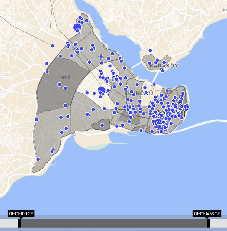
Sample Topographic Visualizations of some of the data currently in CDER:
Note that each point or polygon represents an entry on a single object, which in the eventual published version will open to present basic information, inter-links to other objects, and hyper-links to relevant external digital repositories and sources.
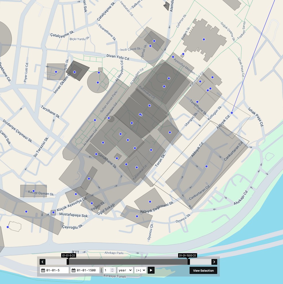
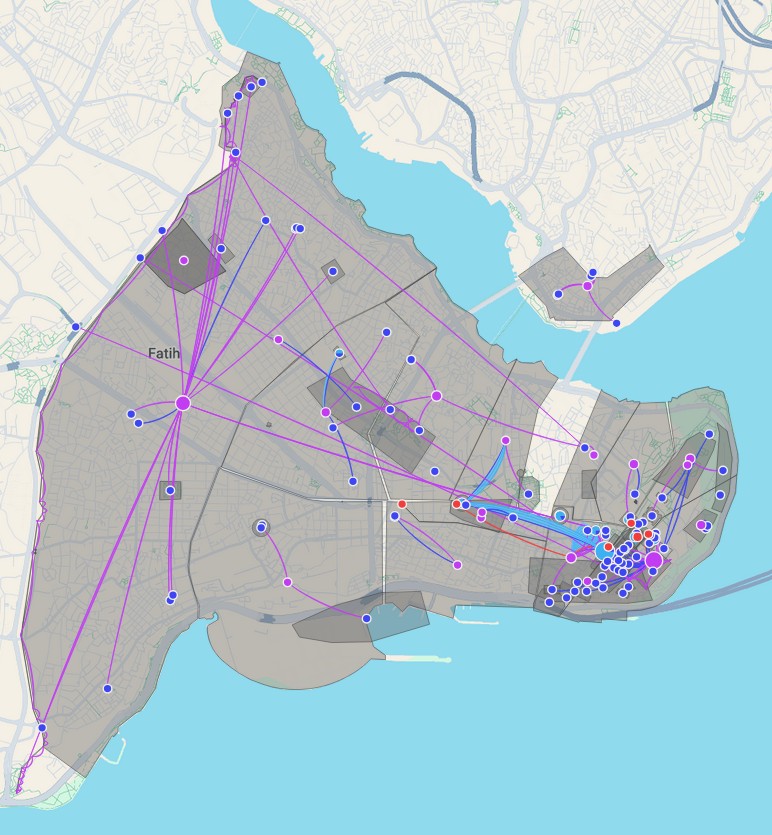
(Left) Great Palace, Hippodrome, Hagia Sophia — — — — — (Right) Statues as linked by City Region